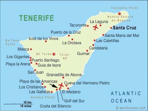
Navigating a new destination feels easier when you understand the layout before you arrive. You’ll find that a Golf Del Sur Tenerife map becomes your best travel companion because it shows you how this coastal resort area flows from the golf courses toward the marina then into the hotel and restaurant zones. You avoid confusion, you get oriented fast and you start your trip with confidence instead of guesswork. This guide walks you through every part of the map so you know exactly what to expect when planning your holiday.
Understanding the Golf Del Sur Tenerife Map: Zones Landmarks and Layout
Where Golf Del Sur Sits on the Island
When you glance at a detailed Golf Del Sur map, you’ll notice it sits on the sunny southern coast of Tenerife near San Miguel de Abona. This region benefits from warm weather almost year-round so visitors appreciate its reliability for outdoor plans. You reach the area from Tenerife South Airport in less than fifteen minutes which means you avoid long transfers after your flight. Nearby towns like Los Abrigos and El Médano appear clearly on most Tenerife maps so you can plan simple day trips without long drives.
Main Sections Shown on Most Maps
A full Golf Del Sur Tenerife layout usually shows several well-defined zones:
- Golf course areas
- Residential complexes
- Marina San Miguel
- Coastal walkways
- Shopping streets
- Hotel districts
- Nature paths and viewpoints
Each zone developed at a different time which gives the area a varied atmosphere. The golf zones feel open and green while the marina feels relaxed with sea views and narrow café-lined paths.
Why Navigation Matters for First-Time Visitors
After you arrive you’ll realise that roads twist gently around the course edges so a map helps you stay oriented. Walking distances can surprise newcomers because the coastline curves which makes places appear closer than they are. Public transport works well on the island yet it requires awareness of bus stop locations so checking a map before you head out saves time and prevents unnecessary detours.
Downloadable and Printable Golf Del Sur Tenerife Maps
Google Maps Overview
Google Maps offers the easiest digital version of the Golf Del Sur Tenerife map because it lets you save essential pins like your hotel, restaurants and viewpoints. Offline maps work reliably here so download the area before you fly. You’ll get live walking paths, driving routes and real-time traffic once you reconnect to data.
Suggested pins to save:
- Marina San Miguel
- Main golf clubhouse
- San Blas shopping area
- Coastal trail entrances
- Los Abrigos harbour
Printable Tourist Maps
Many visitors still prefer a printed map because it shows the whole layout at once. Tourist offices in San Miguel de Abona offer free foldable maps with colour-coded zones, walking trails, bus stops and symbols for attractions. Printed maps also highlight places digital maps sometimes miss like small footpaths or local shortcuts between accommodation blocks.
Resort and Hotel Maps
Most resorts in Golf Del Sur use their own internal maps to show room blocks, pool areas, bars and exits that lead toward the golf course or marina. These maps help you avoid long loops through the complex especially if you stay in a larger resort like Santa Barbara or Aguamarina.
Using the Golf Del Sur Tenerife Map to Explore Efficiently
Navigating the Golf Courses
The Golf del Sur course layout appears on many tourist maps because it occupies a significant area. You’ll see the championship course, the links course and the practice zones marked clearly. Clubhouses sit near the main entry points which helps golfers find check-in areas quickly. If you’re walking along paths near the greens stay on designated trails because golf zones stretch wider than they appear on a small map.
Walking Routes and Scenic Viewpoints
You’ll enjoy one of the island’s nicest coastal walks here because the path winds between volcanic rock, the marina and natural viewpoints. Maps often mark these paths with dotted lines so you can follow the coastline all the way to Los Abrigos. Sunrises look striking from the eastern-facing cliffs so this route becomes popular for early morning jogging or photography.
Driving Routes and Parking Spots
Drivers appreciate maps that highlight free parking around the marina and paid parking near shopping zones. Roads stay quiet most of the year although peak evenings near the main restaurant strip can get busy so a map helps you park smart. Roundabouts connect the area smoothly which makes short drives simple even for first-time visitors.
Accommodation Planning With a Golf Del Sur Tenerife Map
Best Areas to Stay According to Map Layout
Your choice of accommodation depends on what you want from your holiday. The map helps you compare these zones:
- Marina district for sea breezes and sunset views
- Golf course perimeter for peace and long green landscapes
- Central resort zone for restaurants, shops and nightlife
Hotels and Resorts Often Shown on Local Maps
Many local maps include approximated walking times from each hotel to major points like the marina or San Blas centre. This makes planning smoother because you know whether you’ll take long evening walks or short strolls. Hotel clusters also show nearby bus stops which helps families or older guests navigate more comfortably.
Choosing Your Spot Based on Map Positioning
You make better decisions once you see the map because some areas feel quiet and relaxed while others stay lively into the night. For example a resort closer to the golf course offers tranquillity while a resort near San Blas keeps you close to entertainment.
Restaurants Cafés and Bars on the Golf Del Sur Tenerife Map
Food Hotspots Clustered by Area
When you look at a Golf Del Sur food map, you’ll notice clusters around:
- Marina San Miguel
- San Blas shopping square
- Golf course cafés
- Main strip running through the central zone
Each cluster offers different atmospheres. Marina dining feels breezy and calm while San Blas feels more energetic with live music during peak evenings.
Hidden Gems That Maps Don’t Always Highlight
Local taverns often sit behind main buildings so digital maps show them but printed maps sometimes skip them. These smaller venues serve traditional Canary dishes like papas arrugadas or grilled octopus which makes them worth finding.
Building a Food Itinerary From the Map
Use your map to create a simple route that links multiple food stops especially if you plan an evening walk. You could start at the marina then follow the path to San Blas then loop toward your accommodation.
Transport Guide: Using the Golf Del Sur Tenerife Map to Get Around
Bus Routes and Stops
TITSA buses run through the area and connect to Los Cristianos and Costa Adeje. Maps show key stops along the main road and near San Blas. Timetables run frequently during the day so navigating the island becomes easier than most visitors expect.
Taxi Points and Rideshare Areas
Maps mark taxi stands near the marina, hotel entrances and roundabouts. These stands give you quick transport options when buses run less frequently at night.
Cycling and Scooter Routes
Cyclists enjoy coastal paths that appear on many digital maps. Scooter rental shops sit near central areas so riders find them easily when exploring short distances.
Map of Attractions Near Golf Del Sur Tenerife
Within Walking Distance
- Marina San Miguel
- Natural rock pools
- Small volcanic beaches
- Scenic lookout points
Short Drive Attractions
- Los Abrigos village
- El Médano beaches
- San Miguel de Abona old town
Day Trip Destinations on Larger Tenerife Maps
- Teide National Park
- Puerto Colón
- Costa Adeje beaches
- Los Cristianos port
A wider Tenerife map helps you judge driving times so you can plan several day trips without feeling rushed.
FAQs About the Golf Del Sur Tenerife Map
Do resorts provide maps?
Most do because guests want clear directions to pools, restaurants and exits leading to paths.
Is the area easy to navigate?
Yes because landmarks sit close together.
Are free maps available?
Yes at tourist offices and many hotels.
Which map is best for first-time visitors?
Digital maps help most people although printed maps remain useful for exploring on foot.
Final Tips for Using Your Golf Del Sur Tenerife Map
Before you travel download a digital version of the area so you can navigate offline. Mark your accommodation pin then add nearby bus stops, supermarkets and scenic lookouts. Keep a list of must-see spots so you move confidently through the area once you arrive.
Suggested Pins to Save
| Location | Why Save It |
| Marina San Miguel | Dining routes and boat trips |
| San Blas | Live music and restaurants |
| Golf clubhouse | Easy meeting point for groups |
| Coastal path entrances | Ideal for sunrise walks |
| Nearby villages | Quick day trips |


Leave a Reply